
Products
Filters
Marketplace

- Paper
- Policy Brief
- Report
Biodiversity and nature-based solutions: Analysis of EU-funded projects
The EU Biodiversity Strategy for 2030 aims to secure healthy, resilient, biodiversity-rich ecosystems that deliver the range of services essential to the prosperity and well-being of citizens. Nature-based Solutions (NbS) – with healthy and biodiverse ecosystems at their core - are central to
- Document
- Guidance
OpenNESS Synthesis paper: Good governance
Governance of ecosystem services (ES) and natural capital (NC) is one of the four major challenges addressed by OpenNESS. The term governance indicates a mode of steering that differs from state-centred top-down command-and-control approaches, as it is marked by the inclusion of a variety of actors
- Dataset
- Document
- Training
Assessment and mapping of ecosystem services - Development of methods for assessment and mapping of ecosystem services of marine and inland waters
The general purpose of the project "Development methods for assessment and mapping of ecosystem services of marine and inland waters" is to help stop the decrease of biodiversity in water bodies and damaging of ecosystem in the European Union by supporting the preservation and restoration

- Document
URBAN GreenUP Climate Change Challenge Catalogue
This report provides a useful tool for the standardisation of a method to identify and evaluate cities in respect of several societal city challenges. Such a tool will allow practitioners to be able to examine these challenges in a simple way with accurate information about how these challenges
- Guidance
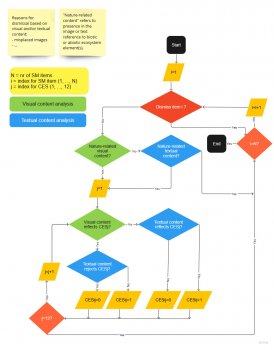
Standard Protocol for the Classification of Cultural Ecosystem Services through Social Media data
Collectively designed standard protocol for coding CES from crowdsourced data. It includes the following files and a video tutorial to facilitate its implementation by other researchers: - Protocol.doc: a document with the general instructions on the procedure for coding; - Annex 1. CES coding.

- Empty
QUICKScan
QUICKScan is a tool to facilitate the decision process in participatory settings. By including stakeholder knowledge and preferences and the ability to calculate impacts in-situ, QUICKScan combines tacit expert knowledge with available spatially-explicit monitoring and statistical and uses
- Document
- Guidance
Method Factsheet - Smartphone App
The MapNat tool is designed to be applied by citizens and scientists who are interested in mapping the use of mainly cultural, but also some provisional and regulating, services and disservices. MapNat enables its users to map ES in three different ways as points, lines or areas on a map on their

- Document
- Guidance
The SPIRAL synthesis report: A resource book on science-policy interfaces
This is a resource book on good practices to improve the effectiveness of existing science-policy interfaces or develop new ones. The resource book synthesises information gathered and research done throughout the SPIRAL project (‘Science-Policy Interfaces: Research, Action and Learning’). The
- Software
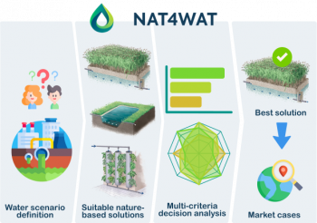
Nat4Wat
Nat4Wat is a free, web-based tool designed to help users select the best nature-based solutions for wastewater treatment and stormwater management. It works by guiding users through a step-by-step process, where they enter information about their water needs and site conditions. The tool then

- Dataset
The Copenhagen global avian distributional database
Distributional data for more than 10 000 species of birds for all land and non-pelagic species was mapped for each species at a resolution of 1x1 latitude-longitude grid cells.
- Document
- Event
- Product
- Report
People with Nature: Busting 24 Myths to Reverse Biodiversity Loss and Drive Transformative Change through Nature-based Solutions.
As climate change and biodiversity loss intensify, the persistence of certain myths can hinder the transformative change needed to build more sustainable societies. Preconceived ideas rooted in outdated practices or incomplete truths can slow down this change by hampering awareness and obstructing
- Report
Mapping environmental risks and socio-economic benefits of planned transport infrastructure: a global picture
This technical report investigates the benefits of planned road and rail transport infrastructure projects for society and the economy, as well as the consequences for biodiversity and ecosystem services. To date, impacts of infrastructure development on ecosystem services have not been widely

- Report
CLEVER Regional Solutions Catalogue
The CLEVER Regional Solutions Catalogue seeks to elevate the role of nature-based solutions (NbS) across the urban landscape. It aims to inspire uptake and continued energy for implementing Nature-based Solutions that meet the varied needs and requirements of modern cities.

- Report
Implementation of the NbS Framework in Fast Follower Cities
This Deliverable details the implementation of the Connecting Nature Framework in the Fast Follower Cities. Generally speaking, the cities have highlighted that the Connecting Nature Framework report and the narrative are useful tools for internal use, as a mechanism to share information on nature-
- Dataset
- Document
- Guidance
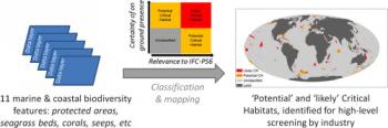
A global map to aid the identification and screening of critical habitat for marine industries
This paper provides a global map to identify potential and likely marine and coastal Critical Habitat, as defined by 'International Finance Corporation Performance Standard 6'. Eleven biodiversity features are identified which can be used as an early screening aid by industries and
- Report
Nature-Based Solutions for Coastal and Riverine Flood and Erosion Risk Management
Canadian communities and infrastructure are vulnerable to coastal and riverine flood hazards. The risks associated with coastal and river flooding are escalating as a result of development in river floodplains and coastal zones, and the effects of climate change on flood and erosion hazards. There

- Video
Nature-based solutions in the GrowGreen cities: videos
As the evidence base on the role and benefits of nature-based solutions (NbS) grows rapidly, these solutions are featuring with increasing prominence in global climate change policy, stressing the importance of their implementation in urban environments. The Horizon2020 project GrowGreen has
- Document
Carbon accounting for PES
The economic aspect of sustainable forest management is crucial for preserving rural areas, highlighting the need to develop methods for quantifying its ecosystem services.

- Guidance
ZÖLD-KÉK INFRASTRUKTÚRA: Zöldinfrastruktúra útmutató - Segédlet zöldinfrastruktúra fejlesztések tervezéséhez, megvalósításához
Az önkormányzati döntéshozatal egyik eszköze a zöldinfrastruktúra-fejlesztés, amely az ökoszisztémák szolgáltatásainak felhasználásával a szürkeinfrastruktúrával ellentétben úgy csökkenti a környezeti és klímakockázatot, javítja a települések alkalmazkodó képességét és a helyi életminőséget, hogy
- ‹ previous
- 13 of 41
- next ›